Orval Van Horlick and Alec Munro
- CA SQPL 01-016
- 1927
Orval Van Horlick on right and Alec Munro on left setting up tent in Britannia, 1927.
Orval Van Horlick and Alec Munro
Orval Van Horlick on right and Alec Munro on left setting up tent in Britannia, 1927.

Alec Munro's horse team packing pipe to Utopia Dam, Britannia.

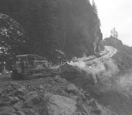
Building railway through Cheakamus canyon

Huey Mills and Kate Mills (formerly Mrs Allan Rae) sitting in the background. Man in the foreground is unknown.
Research compiled by Eric Anderson, 2011: This photo, apparently taken by one of the Magee brothers, shows the construction phase of the flume project. The occassion is a visit to the site by Hughie Mills' new bride Catherine, the former Mrs Allen Rae, in the Spring of 1910. In this photo, Hughie Mills appears to be giving his wife a tour of the project. Mills was a building contractor in the valley, and very likely worked on the flume construction. The location is at the west side of the Squamish Timber Company camp, just above the bank of the Brohm River, which is to the left from this scene. It is difficult to tell from the photograph whether the water for the flume is being led from the Brohm River (in the back and to the left of of the photo) or the Cheekye River (around to the right). Either is possible. The Squamish Timber Co. camp and the beginning of the flume lies between the Brohm River and the Cheekye River. Water for the flume might be more easily taken from the Brohm( closer), but the Cheekye has the steeper gradient. The larger the logs to be flumed, and the steeper the grade, the more water is required.

417477 Government Road
This lovely log house was built by Charles Schoonover in 1932. Having worked as a hunter, trapper, and logger further up in the valley for nearly 30 years, Schoonover settled his family here in a house that reflected the beauty of the forests he loved.
Original use: Private residence.
Current use: Private residence.
Current condition: Very well maintained.

Construction crew at the site of Bracken Arms Hotel
Construction crew at the site of the Bracken Arms Hotel. Picture taken around 1909 - 1919. Lance Bracken on far left and his brother Dick Bracken sitting cross-legged in the center (both are sons of John Bracken). The second man from the right with the baby is Forbes, a friend of the Schoonovers.

Trapping shelter at Elaho built by Charles Schoonover. The men belong to Mather's logging outfit. Photo taken around 1908 - 1909.
Elaho River forms the west branch of the Squamish River. It is named for the Indian word meaning "good hunting area".

Charles Schoonover building home
Near the Brackendale Store.
417477 Government Road
This lovely log house was built by Charles Schoonover in 1932. Having worked as a hunter, trapper, and logger further up in the valley for nearly 30 years, Schoonover settled his family here in a house that reflected the beauty of the forests he loved.
Original use: Private residence.
Current use: Private residence.
Current condition: Very well maintained.

Grading the road from Squamish to Cheekye
Part of Squamish Valley Museum (Brightbill House) Photograph Collection
Grading the road from Squamish to Cheekye (30-35).
Left to right: Claude Hertnell, Lawson Rae.

Line of cars waiting due to road grading
Part of Squamish Valley Museum (Brightbill House) Photograph Collection
Highway 99 (?)

Part of Squamish Valley Museum (Brightbill House) Photograph Collection
Location unknown.

Evelyn Lamport on Merrill & Ring railroad trestle
Evelyn Lamport on Merrill & Ring railroad trestle (present site is just north of Ayr Drive in Garibaldi Highlands). Built along the face of rock bluffs. Photo taken ~1928 on the way to Alice Lake.
Merrill and Ring, an American company bought their claim in 1888 for 25 cents per acre. This went from Valleycliffe through the foothills to Brohm Lake. They did not set up in the valley until October 1926. The operation had come from Duncan Bay, before that they had been at Camp O near Alert Bay. Their first camp is where Valleycliffe is located now. They employed 200 people. The hiring was done by Loggers' Agencies in Vancouver. They would fall the trees with cross cut saws then haul the logs with a steam donkey to the train. They used a steam axe to split the wood as machines used only wood fuel at the time.
A lot of Merrill and Ring timber was burnt in a Norton McKinnon fire in 1927. The McKinnon's engine was given as payment. Aloysius McNalley and John Broomquist collected it. The same year, Arthur Edwards assisted in the building of the Merrill & Ring camp at Edith Lake.
In 1929, Merrill and Ring moved their operation across the Mamquam valley to Edith Lake east of Alice Lake. A settlement of 225 men was set up there. Railway track covered the mountainside from Cheekye River southward.
Merrill and Ring closed in 1930 due to the low price of logs during the Depression. Logs were selling from 5 to 6 dollars per thousand. At this time, the logs were hauled by train to the dump at the mouth of the Stawamus River. Merill and Ring started back up in 1932.
Merrill and Ring shut down 3 times in 1937: after New Years due to snow, due to fire season, and in the fall when a bridge over the Cheekye River was washed out. Merrill and Ring left Squamish in 1940.

Merrill & Ring "4 Spot" with low built steel laying flatcar
Merrill & Ring 4 Spot with low built steel laying flatcar, ~1928 in Stawamus Valley. Climbing 6% grade on branch that ran south to Bughouse Heights.
Photo by: Ed Aldridge.
Aldridge, Ed

Merrill & Ring Bridge over the little Mamquam
Merrill & Ring Bridge over the little Mamquam (Mashiter Creek) picture taken looking north showing sky line for taking Pile Driver to north side of canyon (1928 - 1929).
Left to right: Brian Buckley (?), "Big Dave" Thompson (steel boss-track layer), Freddy Tom (Merrill & Ring car builder son), Billy Dawson (?).
Photo by: Ed Aldridge.
Mashiter Creek was named after William Mashiter.
Aldridge, Ed

Laying steel over Merrill & Ring Mud Creek Bridge
Laying steel over Merrill & Ring Mud Creek Bridge, 1927 (now called "Ring Creek").
Photo by: Ed Aldridge.
Aldridge, Ed


Construction of BC Tel on Cleveland Avenue with the Firehall in the background. Finished in 1950.

Road construction from Squamish to Britannia, 1939


Work at little Stawamus bridge
The actual Indian spelling of Stawamus is STA-a-mus and is a variant of Squamish and means "birthplace of the winds". Pioneers often used "Stamish" instead of "Stawamus". The name refers to the Indian reserve at the mouth of the Squamish River (Reserve #24), the Stawamus River, the area drained by it and the "Chief".
Squamish Public Library, Squamish Files: Place Names.

Construction of new M Creek Bridge